Phase 3: North Cape, Finnmark, & Lapland
Whilst I was ensconced at Abisko it seemed worthwhile to take stock of the expedition so far. I did an audit. (When you're on your own and there's no-one to bounce ideas off, it's mentally and logistically healthy to 'stop' the exped every so often to look as objectively as one can at the overall picture.) So....What have I achieved? Where have I been? Has it been successful so far/to date? There were many more questions that I set myself to answer.....I think the final list filled a sheet of A4.
I'd driven 1,820 miles to get here spending £171 on fuel: 55 gallons, that is 33mpg, pleasingly beyond Solihull's best expected figure for a Defender carrying 250 kgs (ie quarter of a tonne) of kit. That is 2,930 kms spending NKr 2052, purchasing 252 litres aat 11.6 kpl. I had done six major interviews and or work placements (was just about to do my seventh). I had eaten through about a third of my food supply - which of course, if you've stayed with me this far was continually topped up to give me, always, 20 days supply in the Land Rover.
The plan I'd put together way back in June last year was actually working, linking all the various agencies at this unpredicatable time of year in this, the most difficult of all European countries to negotiate a straight route. The funding, the vehicle, the navigation - as well as the mental stamina - all played a big part. Winston was barely broken in - and I wasn't about to thrash it - but it had performed brilliantly so far: 1in2 gradients, temperatures at double figures below freezing, 250 kgs of kit (and rising), fast 'motorway' (well what the Norwegians would call motorway!), off road conditions, driven across landslide debris...we'd done a lot and come a long way.
I was 21 days out of Kristiansand, and had successfully established a routine: breaking camp, cooking, driving, interviewing, researching, re-victualling, and resting. And it all worked. The one key that I had been worried about was the long-range solo driving; it evolved it's own sort of 'in-house' rules. See Appendix. It was all common sense but it's not driving with a colleague so you must be aware of your levels of alertness. Norway especially was the easiest place to drive off the edge of a precipice road.
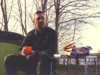
I ate very well at Abisko, spent a good mountain day exploring south west through the National Park, seeing no-one, got my washing done, bought a ton of souvenirs and pressies for family and friends, did yet another re-sort of the kit in the back of the Land Rover, and got an all-important long evening interview with Marten Johansson. Wiry, short, dark-haired and sharp eyed, Marten looked at me warily and quizically but warmed once I'd introduced myself, and my reason for being at Abisko. In the staff restaurant with copious amounts of strong coffee we swapped ideas, research, and many, many stories.
Marten was clearly a professional, and appeared to be a switched-on leader. It turned out he is the Chairman of the Swedish Climbing Association's Safety Committee. This was one of the so-called 'coincidences' that I came up against on this exped, to my advantage. Marten was the person I would have spent a long time looking for in Sweden. And here he was.
Diary Entry (Kungsleden) from Abisko: Day Climb
"Wide river running white water, muddy footpath route, and occasional shelters - bothy types, with fire hearths and windbreaks. Cabin loos too....bridged two wide rivers on back-woods suspension bridges - impressive. This is 'The Kungsleden' route - The King's Trail that goes through the remotest of all NW Sweden. Tracked elk, marten, deer, hare, and saw a willow grouse; yesterday saw an eagle . Very varied - and privileged to see it all. Had a distant view back to [the lake] Tornetrask. Did not quite reach Abiskojaure [lake], just metres away from it. Snow was thick on the ground (here in the upper reaches of the glacial trough) with a not-so-solid crust. I walked and climbed about 16 kms today, beaten only by rotten snow, and as was to become the norm, the snow was too soft for crampons (in my sac) but too deep and wet for boots. But nevertheless, an excellent day all-round."
My route away from Abisko Mountain Station at the end of my stay took me back into Norway via Tromso - reliving old memories of 23 years ago. At least that was my target once leaving Abisko. I had to get through a blizzard first; as I packed the wagon, the wind picked up and snow came down - or rather across, stinging and fast. I got on the road pretty quickly once I'd done a PETROL check. It was only 70 klicks back to the E6 but I had to negotiate the Bergfjellet. And what a journey.
In those 70 kms I saw just one car - and an elk, the landscape turning white again. This time I didn't record a piece to camera but savoured the warm fug of the Land Rover's cab. It was really enjoyable though not a little strange being so isolated and remote. Even more so in a way because Tromso was going to be the last sizeable settlement before the North Cape, should I get there, as it was taking longer than I expected to get to the west coast; I raced, I must confess, the last 50 kms from Abisko. Had it not been for the need to contact Stein Tronstad, Marten Johanssen's Norwegian counterpart, and to process some paperwork at the library and posthus I would have moved on to Lyngen and Nordreisa; as it happened I was hamstrung at every turn - people not available, places closed, the weather grim. But by now I knew how to take advantage of these stumbling blocks, and fed (another confession....at MacDonald's) and re-victualled in town before a long overnight/over-twilight drive to Skibotn and a cabin next to the river. Perfect.
ABOVE LEFT: BJH up-country in Abisko National Park; ABOVE RIGHT: Lapporten from Abisko (Courtesy of Kungl. Vetenskapsakademien) BELOW: The Kungsleden
Between here and the North Cape and down into central Sweden via Finnish lapland was serious terrain and wilderness. I wasn't under any illusions about the need for being well prepared and equipped. Thus the following morning - early - I went further than just a re-sort of the Land Rover. I took everything out - down to the last spare washer set in the cubby box; after giving Winston a comprehensive wash (and wax of course) he looked as though he was on a car dealers front forecourt; there wasn't a single thing in the vehicle; I laid all the kit out on the gravel in front of the cabin and carefully stacked it back with the most-likely-to-be-used ever closer to the top; unsurprisingly it all went back in with a neater fit. Late last night just before Skibotn I'd found a 'Til 24' service staion with integral shop so I'd stocked up with essentials: milk, a lot of bread, margarine, 3 kgs of cheese, a 'tonne' of fruit plus some 'fresh' (vegetables). Chocolate as you'll know by now was, with mineral water, awash throughout the vehicle. I was self sufficient. I changed into some warmer gear and was on the road around a UK's morning rush-hour time, except I didn't see another vehicle for 3 hours.
Here I was moving from thick taiga out onto sub-Arctic and Arctic tundra, the journey down the eastern side of Lyngenfjord being full of very fond memories from '79 when I walked this route. Viewing Arnoy (PICTURE: RIGHT BELOW) some 70 klicks down the fjord was magical - or was it miragical because it seemed to hover on the northern horizon for long into the journey.
The sense of 'overlanding' was very strong today.
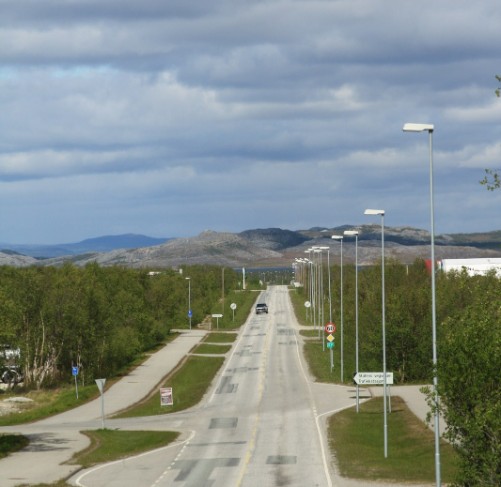
I'm 400 miles north of the Arctic Circle, ready for a few more interviews, and if possible a long trek into the wilderness somewhere - preferably in the Finnmarksvidda roughly to my east. But for now the tyres humming at a steady 60 kph taking me through Storslett, past Kvaenangen, heading for Alta, small settlements, mainly farms, lined the road at random, still with the deep red painted buildings with white window frames seen all across Norway and Sweden.
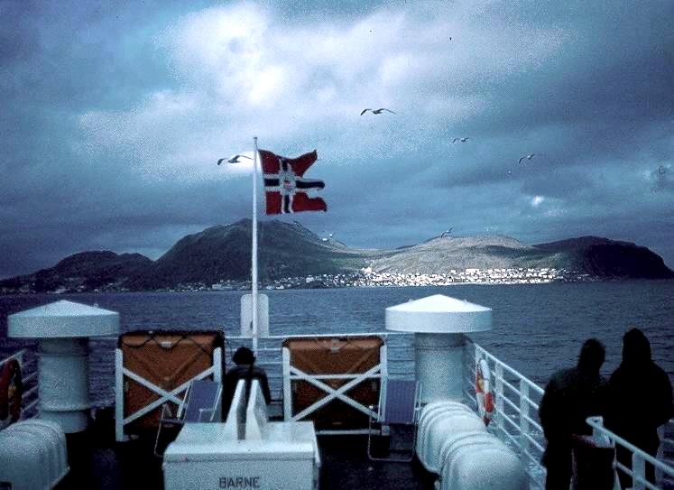
I was still stared at by the locals just as I had been down in Viblemo near Lindesnes three or four weeks back, the Land Rover turning heads.
It's good to be here!
ABOVE: Descending from Duoddar on the Arctic Highway heading for the North Cape. BELOW: Few pics of me at the North Cape, but yes, I made it! Camera resting on Winston's bonnet for reasons you'll know if you've followed the story all the way!
ABOVE: Mageroya, the island upon which the North Cape is located. Winston was the only vehicle on the complete journey across the island save for a fleet of Wallace Arnold's 'doing Norway' and rushing back to catch the Hurtigrute. On the horizon, extreme left, you can just make out 'The North Cape Hall', Norway's biggest rip-off.
I left the Arctic Highway at Olderfjord still heading north. I didn't stop. Route 69 took me alongside Porsangerfjord, the largest fjord in Europe. Here, along a totally deserted road - I saw no traffic for 74 kms - and at the water's edge, with typically very heavy grey Arctic skies, empty water, and no-one living here it started to snow. I had to stop. It wasn't that I wanted to get out and savour the remoteness, however palatable that would be, it was that I needed to rest.
My eyes were sore, my back ached, and I needed to stretch, eat, and drink. "Just beyond the Skarvberg tunnel I'll stop" I remember saying. And so exiting the tunnel down a sharp left hand bend into a small cove....and....picnic tables and toilets! Perfect timing. Still no traffic.
The diesel died quietly and obediently, door opened, and the chill wind coming off the plateau above me made me remember I was in the Arctic; HH Field Jacket on in double-quick time and the volcano kettle steaming away whilst I dug out some scoff - and a hat. All the while a large herd of reindeer were quietly gliding across the fell side in front of me.
Sure it's the wildlife's sole right to be here, but I reasoned also that maybe, just maybe, I'd earned some brownie points in almost successfully completing this phase of the expedition, the longitudinal transect of Norway and had, I hoped, so far not upset any of the local trolls or djinns. Perhaps my 'right' to be here is sound after all.
The road got more serpentine the closer Winston and I got to the northernmost part of the mainland at Kafjord, the old ferry terminal where I alighted all those years ago. It was so wild outside the Land Rover - gusts moving the vehicle bodily sideways as I turned the hairpins, "....violent snow squalls with clouds racing across a copper sky" as my diary states. I descended the fjordside this time into the new tunnel. And what a tunnel: 6.87 kms long, and it goes 212m below the sea floor at a 1:10 gradient. When I drove into it there was a fog near the bottom so pitch black, with fog, and no other traffic makes for (to say the least!) an eery 7 kms journey. And a very expensive one at £21 each way. I'd much rather have used the ferry if it had still been running (archive picture from 1979 right above looking north back to Honingsvag).
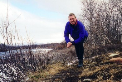
ABOVE: Looking east down into Fiskevik whilst on a leg-stretching hour's trek across Mageroya, true mountain and plateau tundra.
Once through the tunnel and onto Mageroya I entered different weather. As clear as a bell too, and the fantastic colouring of the island - magical yellow ochre, chocolate-brown, and the white of small snow-fields, surrounded by deep blue seas, and white surf, all mixed in with ocean-blown clear air.
Twenty minutes late I was up at the North Cape, and toll-booths. "What the *********????!!" Toll booths? Surely not for access to the Cape? They were. The cost was a stinging Nkr 185 (£20). There was no other traffic as I gingerly headed for the booths down a gentle gradient - six of them in dead ground not overlooked by 'The Great Hall' some 300m further on over the crest of a rise ahead of the booths. I stopped.
A Mexican stand-off then between me and the booths. It was me at the O.K. Corral a la Tombstone. I wasn't paying - and that was final. And I didn't drive 4,000 klicks to be turned away.
I waited.
No-one around.
Winston was growling gently in the Arctic air, facing north, on a vast stretch of gravel still outside the fenced Cape area. I watched carefully to see who was controlling the booth. Wind buffeted the vehicle.
I let out the clutch and did a 180 driving south - away from the Cape then immediately did another 180 having got plenty of distance between me and the booths - picked up not inconsiderable speed and 'hit' them at over 30 mph - didn't stop to pay - shot right through and accelerated all the way up to 'The Hall' .
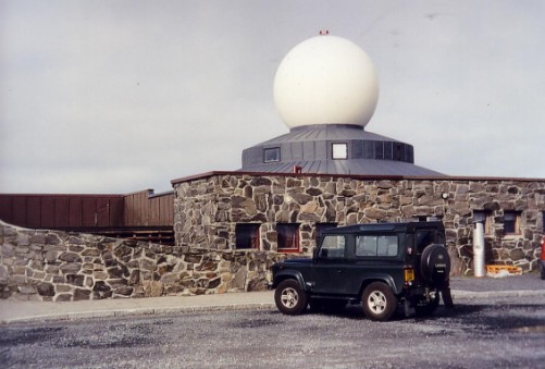
Before anyone had a chance to realise that this mad Englishman had driven through I'd parked round the back of the building with it's big white radar dome, and was walking away. There were just four other vehicles there. It was free in '79. Outrageous.
________________________________________________________________
I serpentined back down the road to Honningsvag, 34 klicks away; tanked up with diesel in the Shell station just outside of sentrum, and recognised the guy from way back in the 70's. The weather was mild as I padded across the forecourt to fire up Winston again; but we were staying local as I wanted to get a few souvenirs for the folks back home. The trouble was the clock struck 4pm on the Land Rover's dash as I drove on the sweeping left hander into town - and of course everything's closed by 4 in most Norge settlements....but the bookshop was open. Good stuff. Got chatting to the two assistants in the shop about staying overnight here, but as I had a telephone link-up booked with the BBC for tomorrow I reckoned that being a bit further down the road would help. I wasn't wrong as it turned out.
So, time to put some latitude between me and the North Cape. I made a momentous move. I turned the Land Rover round and faced south.
Now this expedition doesn't usually do 'south'....it's all 'north' and so it really did hit me that a new part of the exped was beginning. Bring it on.
By 7pm I was ensconced in Solstad camping in Lakselv and trying to sort out a phone to use; as is common to this journey, the Shell Service Station obliged and with trial calls out to Gary, and he to BBC Engineering we finally went live on air at 8 am London time the next morning.
However, important now was rest and food, and drink - lots of tea.
Diary:
"So, a day of records: first, yes, reached Nordkapp 'the hard way', second, drove 500 kms today breaking (unintentionally) my endurance-to-speed record set on Day 1. Third, drove down into and through the world's deepest undersea tunnel at -212m; fourth reached 659 miles north of the Arctic Circle - you can't go any further; fifth, a record rip-off would have been Nkr 455 (£36) just to get to Nordkapp. No way" Today (2011) it would cost £80.
After copious cups of tea and a large vegetable curry I had an early night, ready for the BBC at 9am local time tomorrow. The link went well partly due to Kim Ruben Broks the counter assistant in the Service Station, and the owner who both plied me with coffee. Kim turned out to be a graduate of the Alta folkehogskole, a place mentioned by Per Nilsen way back at AF. I had spent two weeks trying to track down someone who'd been through one of these schools - and here he was. Just another of the expeds remarkable coincidences.
RIGHT TOP: Lakselv's main drag. RIGHT BOTTOM: Winston...hot-to-trot and about to leave Solstad Camping on Lakselv's east side. You can see the load level inside Winston: too high! This came about regularly because of the difficulty of replacing kit in exactly the right place after use - so it built up and up; plus I was acquiring more stuff almost everyday from new kit, to publications, to the odd set of antlers....today's run was planned to be relatively short over to the Russian border near Kirkenes so I'd have time to sort the back. That was the plan anyway.
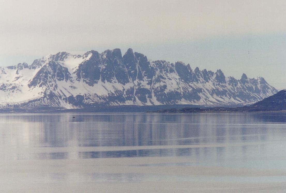
ABOVE: Arnoy
Route so far:
KRISTIANSAND - LINDESNES - EVJE - ODDA - KINSARVIK - BORLAUG - STRYN - ALESUND - MOLDE - KRISTIANSUND - ORKANGER (Trondheim) - STEINKJER - ROYTVOL - ALSTAHAUG - BODO - ABISKO - ALTA
And so it was that around late afternoon on a day of clear blue Arctic skies I drew up by the Altaelva River on the Kautokeino road just south of Alta to camp for the night. A long run through from Skibotn this morning had left me tired but chuffed to be here. I enjoyed the riverside location....sorted out the best site for the tent and quick-pitched the Solar II whilst the volcano kettle was boiling water for a brew....in 1 min 50 secs for two pints of water. Not bad and I hadn't even got the flysheet pegs in when steam began pumping out of the spout. It's a contender for my 'Top Kit' Award.
I had to get a message out to Gary as it was a few days since I'd been in touch. I never knew what the phone link would be like from up-country Norway to Leigh-on-Sea and it was always possible that I had so little credit on my phone card that the only message I could get out was "I'm ok and at x." This call was different. Gary said the BBC wanted to do a live phone link with me the day after tomorrow to discuss findings, progress, and 'What it's like up there.' No doubt they'll ask all the standard townie questions: "Do they live in igloos?!" "Have they got television?!" and "Where do they go in winter?"
However for now after reporting I was well, safe, and near Alta, another brew, and a big, big, meal - Lancashire Hotpot - was the order of the day. It was warm enough, wearing a woolly-pully, to sit outside and brew and scoff, scoff and brew my way through the late afternoon/early evening, a late 'lunch' merging imperceptibly with a huge evening meal of Chicken Curry, then bananas and custard - and yet more brews. The volcano kettle was on constantly whilst I sat in my comfortable chair ('chairs millionaires' a la Hiddins) reading and working out a solo trekking route across the Finnmarksvidda in a few days time. A bit bizarre at 70 deg north.
Camping was great and what I aimed for every other night, but it was not an option I could use all the time. I needed power charging for all the electrical gear including both video cameras. Cold drains batteries, and human muscle power/energy far faster than the benign temperatures of flat Essex, 18 deg of latitude further south, but this location on this afternoon was as near perfect as I could find and I had no intention today or any other occasion of driving around for hours looking for a site, cabin, hotel, or hostel. I took the first best I could find everyday.
Alta is a bit atypical for a settlement this so far north. Each time I've been up here I've had to sort of pinch myself to remind me I'm in Arctic Norway. First the town is big for Norway, at 17,000, and huge for the region. Second, it has a 'mild' climate with rainfall so low it's regularly described as being less than the Sahara. I would dearly love to know where the travel writers get their information. Third, it's a very sheltered location. I always think it's like driving into Inverness, although a little more suburban, although I'm sure my fellow geographers will slay me alive for such a description! Despite all this it is where I saw my first wild wolf many years ago.
Deep in the forest, looking for Alta Friluftspark A/S, I was ready to put Plan B (a day-trek through the forest to the canyon) into operation if the boss of the Centre couldn't see me. I had no appointment, just turning up 'cold'. If I was running a business (as I do) I would not be too happy with someone taking up my time right now. But I need not have worried.
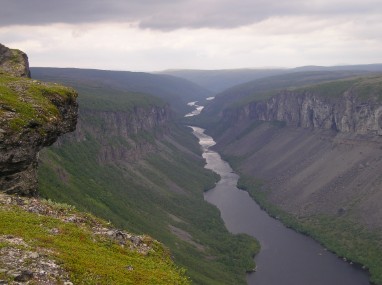
AF is the most northerly private commercial outdoor centre in Norway and every guidebook and tourist info centre from Trondheim north recommends it. This was partly because the Altaelva is fast flowing and scenic, rushing through a 415m deep canyon: the Sautso, certainly the single most dramatic landform in Arctic Norway. And here I was. Or at least here I was in their front garden, because I appeared to have parked on what passed for flower beds. This would not look good to anyone gazing out of the main building to my right, unannounced, loud, and scrunching off-gravel into someone's garden.
Stopping before I drove into the rotary washing line with wet suits hanging drying, I switched off the engine. Feeling awkward, with only the breeze blowing through the pines for company, I really did feel like an imposter. But then a door opened filled by a solid, squared jawed and fresh faced guy. This was Par Nilsen and he just happened to be the boss of Alta Friluftspark A/S. It was his back garden I'd parked in.
We spent a large part of the morning talking; he was a good guy and put me totally at ease; we talked courses, staffing, accidents, qualifications, routes, seasons, and humour before going out to look at hardware, clothing, and meeting a few of the instructors. It was rich, enjoyable and very stimulating, and different again to my other interviews and chats further south. The interesting thing - which I was finding across Norway - was that we had so much in common - we were [all] so much alike. We promised to exchange research.
______________________________________________________________________________________
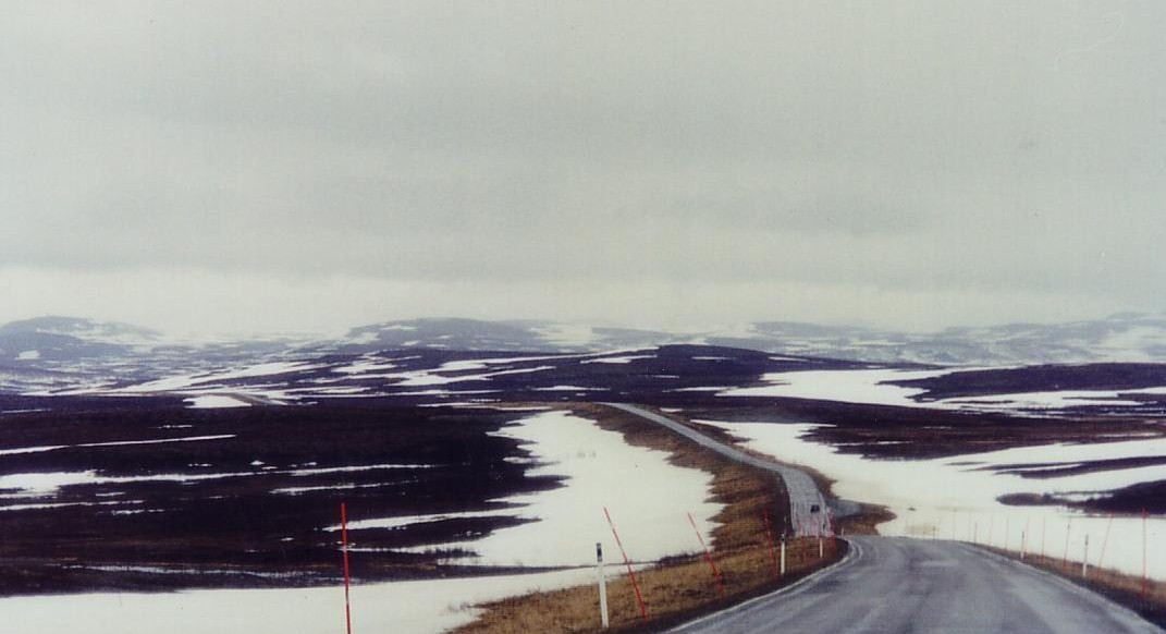
The route was still 'forever north', but not for much longer. I was already at 69 deg 51 mins N and the North Cape was at 71 deg 10 mins N. Looked like a good drive for the rest of the day then! However Alta would be the last settlement for 415 klicks unless I stopped off in Honningsvag on Mageroya Is.. So let's get serious. I tanked up with diesel for Winston, plus jerricans, extra water, plus maps folded, checked the weather forecast with NorgeMet and drove up into the Oksberget. Visibility changes almost minute by minute up here and with driving rain, high winds, and no traffic plus snow still lying thick on the ground (the date is May 15th) on the Duoddar Pass at over 400m. However it wasn't the altitude that was causing the extreme conditions, but the latitude. It's like driving to the most northerly tip of Alaska with altitude added. Point Barrow is at sea level. We're not here!
The tarmac came to an end and oil-based gravel was the order of the day. I slowed to below 20mph and settled down for a long Icelandic-road-type journey dodging gargantuan pot holes, flying stones from the odd on-coming car, and closing the front vents to avoid clouds of dust. Only there wasn't any dust from cars on the horizon, and they were travelling pretty fast from what I could see. Reason? The gravel came to an end remarkably quickly. Since I was up here last, the Norwegian road engineers had worked their magic yet again. The mist descended but so did I, down into a birch-covered Briedalen occupied by the Repparfjordelva, boiling in spate. This was the place to be. Leg-stretching time then, and a stroll above the chasm to take it all in.
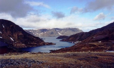
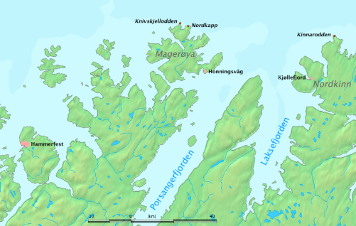
ABOVE: June 1979 BJH travelling south across Mageroysundet on the ferry which predated the recent tunnel. I was spending six months up here walking - amongst other things - south to Lindesnes. The settlement in the distance is Honningsvag. BELOW: The Porsanger Region of Finnmark.
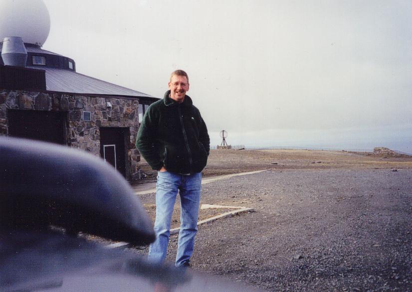
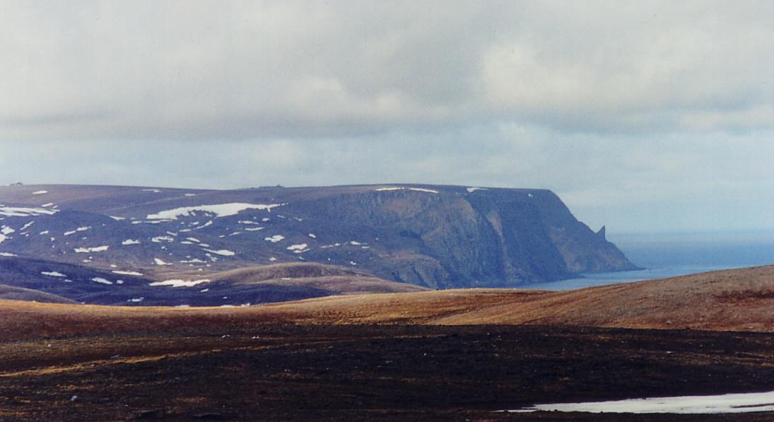
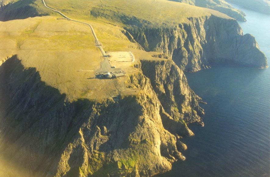
BELOW: The North Cape as seen in May 2002, a plateau some 300m asl.
ABOVE: Winston, having stopped growling, hunkering down behind 'The Great Hall' at The North Cape after our Mexican Stand-Off refusing to pay the entrance fee of Nkr 185. More importantly though we'd made it here! Another box ticked on the expeds list of to-do's. I spent some time re-living old memories, walking across the bare flat plateau, taking some pics - and forgetting about using the video camera! Windchill was around -20 deg C. but this had no effect on my elation to be up here. I drove across the plateau which was a heinous crime. Time to sort some statistics whilst looking out to the Barent's Sea from this windswept clifftop. I'd driven 2,469 road miles from the Lindesnes lighthouse on the 18th April. Today was 15th May. I'd completed the whole longitudinal traverse of Norway by road via the Kystriksveien. It felt good. Time for a brew then.