Phase 4: Finns & Forest ... and more forest
I didn't get to Vadso, my intended destination for the day - or to the Education Office to interview Anita Bello. I'd been trying to contact her since a week before I'd left the UK, but to no avail; four attempts in Norway alone. So, what to do? I was not going to drive a 170-mile journey on a wild goose chase hoping I could find her to talk to. Annoyingly there was no Education Office in Lakselv - only in Vadso. I could sense a major re-plan approaching. I holed up in the Shell Service Station again - for fuel this time, and did a re-appraisal over a coffee at one of the corner tables.
Lakselv, like Alta, lies at the junction of three major routeways. The E6 Arctic Highway comes in from the north, and then tracks off east as Route 98. The E6 goes south to the Finnish border 90 or so klicks away. No comms. with Vadso, so I had a choice: east to Kirkenes and the Russian border, or go into Finland earlier than planned. Solo work brings into sharp relief the lack of a second person as a sounding board in situations like this; experience though has taught me you don't prevaricate - you crack on with the mission based on all the availble information at hand - and make an informed judgement. I decided on Finland, and what became to be the most frustrating phase of the whole exped..
Fortunately my logistics and 7 P's kicked in here so I had currency, food, maps, and time to sort a sustained journey into Finland now rather than in a week's time.
__________________________________________________________________________
I was driving up onto the Finnmarksvidda along the forested valley of the Lakselva - literally the 'salmon river' and along its banks were adverts for companies offering fishing tours, which seemd a bit incongruous with what happened over the next couple of hours.
An olive drab Mercedes G-Wagen drove towards me, passed me with the passenger waving a greeting; "That was a military G-Wagen" I said out loud; then a another - and a small convoy; most waved. There was an excess of miltary vehicles and BVs with large road signs every couple of klicks informing me not to stop, take photographs, use firearms or hunt. Better put my AK74M under the seat then.
Realising I was in a military area my hunch was confirmed when looking up on my left was an MT park with dozens and dozens of BVs and trailers plus a few hundred GS vehicles. The heavily guarded entrance at Porsangmoen announced this was the HQ of the Finnmark Regt.. I drew up at the gates.
The guard sauntered over and asked my business in stopping. (I then twigged that the other G-Wagen drivers had waved because maybe they thought Winston was a military vehicle). Stating what my research was and flashing my (albeit out-of-date) MOD ID card with enough credentials to satisfy his curiosity and questions, he thought and replied that I had no authority to visit the Overlevelse Kompaniet (Survival Training Team) that work out of here. Furthermore he had no authority to let me through the gates. This was all done with a smile however and he followed up this formal announcement with a suggestion that if I could wait ten minutes he'd phone the Team's senior NCO who could perhaps chat to me out here in the car park.
And so it was that Col. Sgt. Daniel Johannes, a Sami responsible for leading, with an officer, a 24 man training-team delivering to recruits a three-part survival training programme here in the most northerly army department in the most northernmost garrison. Daniel was no more than 5' 3". He apologised for the lack of in-garrison hospitality but the country was on a Cat. 2 alert since last September. I plied him with questions about his programmes, locations, strategies, and equipment.....accidents, foreign training, and duration of exercises; he was most helpful even to the point of nipping back into the camp and bringing out two coffees. I shook hands at the gates with a tall blonde officer whom I was told was the boss of the garrison's STT.. Daniel and I exchanged adresses and and a few other items, and then we shook hands and I nav'd Winston out onto the main drag south to Karasjok. The meeting with Daniel Johannes was valuable and really enjoyable - totally different backgrounds - or were they? - but remarkably similar philosophy in our respective jobs. It would have been a good work placement. One day.
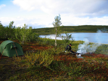
My backpacking sac which sat in the back of the Land Rover could 'go operational' in just a couple of minutes: just add water, grab my cameras and a few bits of legal stuff that I didn't want sitting in the vehicle....and then I trekked out into the 'vidda. And what a special place.
I headed for Vuorje and surroundings - no paths here, just making your own way through the birch scrub. After about seven or eight k's of great walking I saw smoke and gingerly made my way towards a small stretch of water. A single guy was camped; he introduced himself: Nils Anders Malvik. We chatted by his fire. I was heading further west but we chatted some more and I ended up pitching my Terra Nova Solar II near Nils. It turned out he was a retired search and rescue team member formerly from Tromso, and now happy to wander and backpack solo throughout Lapland. We talked until midnight - still light. I was very interested in his take on youth expedition safety; he asked lots of questions too.
By dawn there was a covering of snow but the sun was up so it wouldn't be around on the ground for too long. I brewed up on the hexistove and prepared for an early departure. Nils offered breakfast, but although tempting, I knew he understood my desire to get back on the trail - not that there was one. We'd exchanged addresses so he's going to be a good link in the research.
__________________________________________________________________________
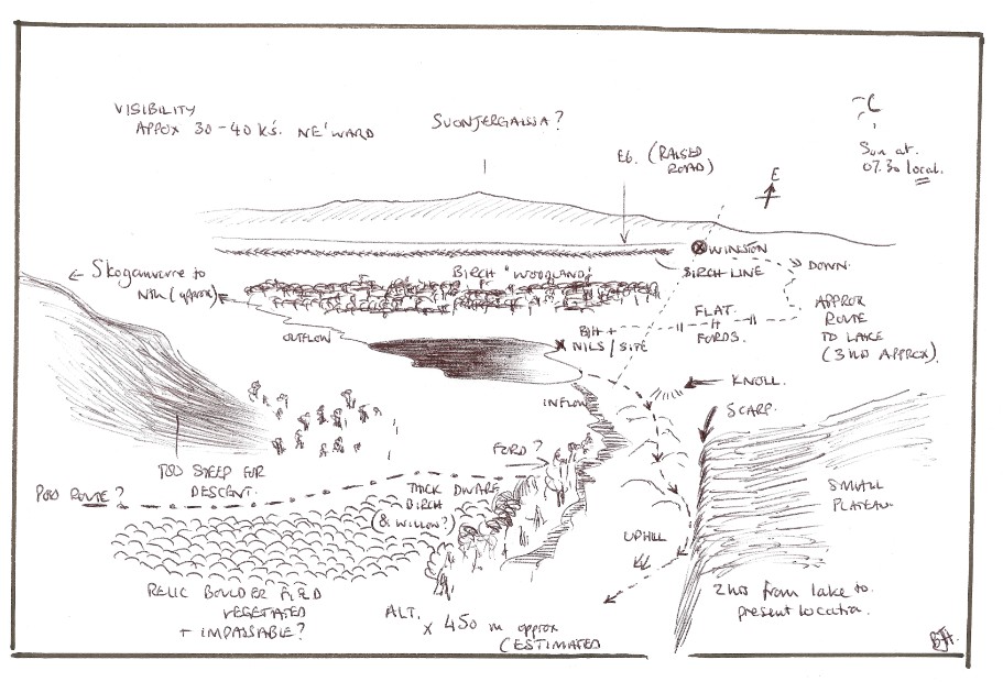
As I'd no large scale map I was nav'ing by landform and what I call 'retro-recognition'. It only really works if you are retracing your steps (or near-abouts) later in the journey, but involves stopping at key points on the route and turning round to make a note (literally is best - or even a sketch or sketch map if you've the luxury of time) of the trail made so far. It works for me every time. With experience I can actually take a different route back (if circular and not linear) and still nav my way with accuracy as long as I'm not too far from the outward journey's route. You have to take account of distance (pacing if possible), landforms, aspect, compass direction, and view. SEE BELOW: one of my retro-rec sketches for that day; I returned on a route just to the north and north-east (ie left of centre) from where the sketch was made.
It's a skill which is very pleasing to develop. It's certainly necessary in areas where there are no maps or where one has no map. Tilman and Shipton used the technique, so did Wally Herbert before he started plane-tabling at the start of his map making in the Antarctic, as did many early explorers, and inherently many of us use the method in less remote areas too. Effectively it's the beginning of producing one's own mental map of an area. This mental map can be as sophisticated as one wants it to be depending upon necessity.
__________________________________________________________________________
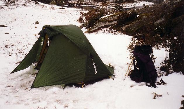
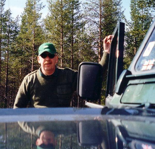
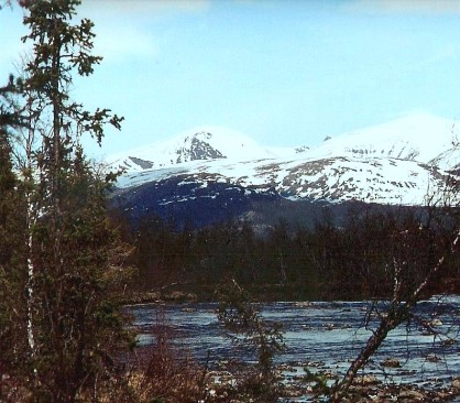
The route south (yes I really was going south - very strange!) - took me up onto the Finnmarksvidda / Finnmárkkoduottar, which gave me a reason to take stock and get some camping in (LEFT & BOTTOM). I drove off the road and found a fold in the ground to park the Land Rover surrounded by birch 'woodland' (BELOW). It was very overcast (looking north here) as I sorted my Berghaus Extreme 7000 sac, and made safe Winston, but the forecast was for clearing weather with occasional snow flurries throughout the next 24 hrs. Good. BELOW MIDDLE: My Solar II with the Extreme 7000 sac: both excellent bits of kit. BOTTOM: BJH resting in the Finnish forest.
It was a great backpack/ 'walk' / bushwhack through the dwarf woodland of the Finnmarksvidda, with some special views. I decided to do something not yet tried on the exped, and that was walk through the 'night' with just a few dozes to keep me alert. Walking through the hills (nav'ing using my sketches and sketch maps) of Lapland at 2am is nothing less than magical especially with an almost clear sky. My energy factor hit a low around 11 pm the previous evening but now I was soaking up the atmosphere and experience. I loved it. Visibilty was good; not perfect but there were no problems trekking. Thus I arrived back at Winston - who appeared to be hiding in the scrub - at about 5am, de-kitted, had a full washdown in the stream about 50m away - freezing cold but very invigorating! - and was on Route 92 long before 6am.
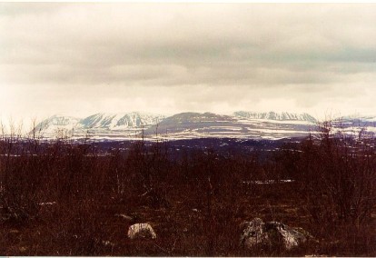
Got into Karasjok predicatably early, but the services I needed were just opening so to get food, fuel, stamps, and even managed to get into the Samelandsenteret courtesy of the Manager who hadn't planned to be at the Visitors' Centre this early....she was really helpful, and after a coffee got back on the road. I'd loved to have stayed but preparation for Finland was very much on my mind - if the maps were to be believed it looks like the Finns invented the words 'remote' and 'wilderness'.
Driving out eastwards on the 92 heading south-east the environment was deceptively benign. Lots of farms, hamlets, and farmsteads, lots of side-roads and quite a bit of cultivated land, but in contrast to this peaceful pastoral scene I began to wonder, in the final 18 klicks to the border, whether I'd regret leaving Norge.
So....across the river, up the hill, through the border and .........nothing...........just an ocean of trees, and a road so straight you feel a bit cheated; yellow sandy soil and not a building in site.
"Welcome to Finland" I said, quietly to myself.
The map shows six 'settlements' along the ruler-straight 98 kms of road in front of me; these turned out to be closed summer-house/cabin sites. And of course it certainly was not summer. The trees started at the roadside.
To the north of me was Kevo Nasjonalpark, and to the south the Muotkatunturit wilderness - vast areas with no boundaries. Being outside a 'wilderness' seemed no different to being in one. I had a feeling the Finns simply drew a line on a map to delineate and official area or two. What a good idea.
I sped through Inari and Ivalo mainly because no-one was answering my phone-calls for interviews etc. that we had arranged way back a couple of months ago. I drove up to Saariselka (a long held ambition) and enjoyed 20 kms of off-tarmac road; the location was good for camping but with young reindeer around and the very great possibility of bear between me and the Russian border just 30 klicks away I erred on the side of caution. I had a good chat with the hostel warden at Saariselka though - a good guy; he suggested that if I wanted an interesting drive I ought to try Raaja Jooseppi on the border. Off I went. Great journey, very remote, with the expected volcano kettle brew on the way; the Finnish Forestry Research Institute (METLA) guys were working near the border where I had another brew stop and I followed them across country to get a short cut back down to Route 4.
I eventually came across a tiny hamlet called Peurasuvanto, on the deserted route south towards Sodankyla. It was nothing less than an oasis in a dark green ocean of pine, spruce, and fir: friendly faces found amidst formidable Finns. What a place!
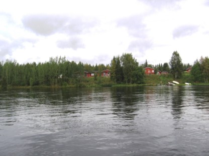
By a bridge over the Porttiipahdantkojarvi's watercourse was located a cluster of cabins, sauna, outbuildings, and a restaurant, all very welcoming, the first buildings for over 15 miles. The owners, Hilkka and Ola were very welcoming, very chatty (unusual for Finns), and helpful with the research. Planning to stay just one night I opted for two; a good call as the cabin was the best of the whole exped., bar none. If Hardangertun was the best in Norway, this was for me the best Scandinavia had to offer. Hilkka and Ola obviously knew their business. I'm sure critics would say that I don't need a 'rest day' what with virtually zero traffic, excellent roads and a loss of interviews.
Diary: "......in fact [I'm finding] this whole exped hard, hard, work. I can't face more big-distance driving again today; desperately looking forward to not being behind the wheel." Driving Finnish roads (and in Sweden for that matter) was soporific at times and it was all too easy to just keep driving, driving, driving. Following my self-imposed rule that I must have a break of at least 30 mins for every two hours of driving, it was often so quiet parked up off the road in a spruce or fir glade, that not a single vehicle would pass during that break.
Hilkka ran specialist outdoor courses from this place: bird watching in summer, river boating (more serious than it sounds), snow-shoeing, skiing, skidoos, fly-fishing, reindeer hunting in winter, and dog sledging. To compensate for my lack of contact with providers in Ivalo, that evening Hilkka was kind enough to talk through various programmes and approaches to clients courses. Obviously the environment is a great teacher out here - to those who are continually exposed to it and to those who want to learn; with winters (especially) so harsh one can't help develop comparatively specialist skills just to enable a semblance of normality and continuity in winter, let alone survival. But of course to townies from England (who do actually visit the Centre here) there's an expectation upon the course providers to deliver safety as a matter of necessity. One might even say that in winter it would be life and death. So growing up with this portfolio of outdoor skills, it's natural to assess and make judgements....and take measured risks. As we don't have this environment in England, and only partly in Scotland, aspirant expedition leaders have to be placed in circumstances to enable training and education of the person, and circumstances have to be engineered to encourage the development of the assessment of risk, hazard, and also the practice of judgement skills. This takes time, money, and the right person.
________________________________________________________________________________________________________________________________________________________
I was kitted up and out early the next day to take full advantage of my 'rest'. It was now bitterly cold with a windchill way below zero but with the best clothing, and my 'green' sac (as opposed to my 'mountain' sac used on my foray into the Finnmarksvidda) already packed and ready to go, I walked off into the deep forest. However - a familiar situation: no maps. None are sold, none are available. So everything was done by landmark and compass, not easy where every tree looks the same. Position of the sun, the river, the Centre, and the use of my road map (yes I even used that too), was put to use to build my mental map. Doing a retro-rec sketch was out of the question here as vis was only about 150m at the most. In less than 60 seconds I was out of sight of my cabin.
It wasn't mountain out here, just low hills, sandy soil, and full of mires. You could easily get trapped by these bogs/lakes although I found a few duckboards, but with my mental map developing along with the use of the Recta 100 compass, minute by minute I was juggling the desire for a good explore with the need to keep safe - and get back again. Then it started to snow.
I found a good site for a brew to take stock, reckoning I could walk for another couple of hours; but the sun had disappeared behind heavy grey cloud so that was one method of nav'ing now out of the equation. Things were getting more difficult. This was excellent training, and it fulfilled another of my aims for this exped: personal challenge.
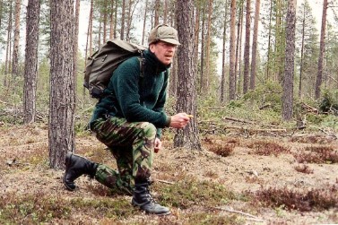
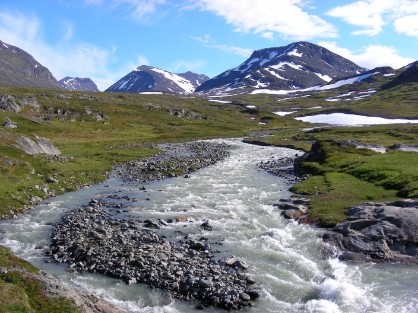
ABOVE: BJH nav'ing through Finnish forest. OPPOSITE: Peurasuvanto from the south side of the Kemijoki River.
After a very good send-off from excellent hosts I drove down to Sodankyla to get my mobile phone seen to - some technical problem, and then through to Kittila. This place reminded me more of a modern version of your average rural Irish town, perhaps somewhere in South Tyrone - long, one street, whitewashed low buildings, parking outside the few irregularly spaced shops and the whole population, what little you see, staring at you; there is no traffic of course. All the main services closed: bank, tourist information, town hall, even the phone box.
The pattern was identical in Muonio. I'd arranged to meet Hannu Tapari a canoe instructor who has just started taking troubled youth from Helsinki on long range backpacking expeds up here, but the phone number given me met with 'unobtainable'. When I chatted to the lass in the Esso service station in town she found another number and said he'd be at the Retkeilymaja; I phoned - no answer, and on drivng over it was closed. Stumped again. Sarkijarventie itself was a dead road. Where is everyone? Having bought two tanks of fuel, food, paid for repair of phone, plus cost of accom at Peurasuvanto I was beginning to run short of cash, and as banks were closed (it was Saturday), until 10am Monday, there was a pear shaped situation developing. I phoned the guys at 'Outdoors' a national advisory team; although helpful they couldn't be repsonsible for lack of contact up here; but they suggested I direct enquiries to them, which I probably will but it defeats some of the object of being up here. Thank goodness for Hilkka and Ola.
I hove-to on a piece of waste ground / makeshift parking-lot round the back of the Esso service station, and did an appreciation, and had a brew. Do I bin Finland? Do I wait? Do I go walk-about again? I'd had eight uncontactable contacts in Finland in just two days. There was a chance that could increase, or I could get lucky. I phoned Ola. He said that regardless of pre-arranged interviews etc., activities in northern Finland do not really get going until 10th June. Today was 18th May. Many instructors go south in this interim period of Spring-Winter. (It is generally held that there are eight seaons in northen Finland) as it's too warm for serious winter work and not meteorologically stable or settled enough for summer work.
In my heart I desperately wanted to stay in Finland. I was absolutely stuck. It looked as though my decision to come south into Finland was the wrong one. I had an overwhelming feeling that I'd be criticised for not staying and ferreting around even more to find the Centres I wanted to look at and the people I wanted to interview, but here on the ground I had to weigh up all of the variables and criteria and make my decision. Fuel was running low - I couldn't get diesel with Travellers Cheques; though I had food in abundance, and £1000 in Swedish Kroner.
I was at my lowest ebb of the expedition.
I decided on border hopping across to Sweden. Phoning Marten Johannsen he gave me, apart from launching a very welcome morale boosting advisory, an additional (to my own) list of people in Sverige to contact should this run of 'uncontactables' continue. As if Finland was determined to hold on to me I just couldn't find the border crossing. It took me an hour of driving back and forth along the banks of the Muoniojoki. Roads ran down to this wide river - but no crossings. I eventually drove up to a dear old lady doing her front garden - and in my faltering Swedish hoped she'd understand; she did and off I went down Route 21; in another 15 mins I was in Sweden.
_________________________________________________________________________________________________________________________________________________________
On the remote, empty, west bank of this border river, I parked up and got out of the Land Rover. I didn't quite know why I was just standing there looking back over to Finland. I think I felt as though I had let myself down. Emotion just washed over me. I couldn't move....I just stood there and looked across the rushing noise of the Muoniojoki. It must have been a good 30 mins before I realised I was getting cold. I remember eventually climbing into the cab, firing up the diesel and slowly pulling away. I wouldn't even look in the rear-view mirror.
Within ten minutes I was back to my old self again....putting it all down to experience. Strange experience though. "Best put in a box with a sealed lid and left on a shelf for a long time" I said to myself.
_________________________________________________________________________________________________________________________________________________________
The distances were vast up here in Norrbottens Lan, with settlements and services very few and far between. I was now on Route 404 heading for the 99; I had to drive north-west to pick up a road to take me south; again, forest closed right in to the very edge of the road; it was clear and sunny through the trees - welcoming. I wish the road surface was. I am so very pleased I chose a 'bomb-proof' Defender for this journey. The tarmac was completely frost shattered and frost-heaved; every 15 minutes there'd be a 'CRASH!' as the whole vehicle fell into holes camouflaged by a thin blister of raised tarmac; Winston coped with it well. Full marks.
It was alongside the road a couple of hours into this Swedish mission (not having seen a single vehicle since the Finnish border) that I found a glade to pull into for a rest-and-brew-stop a la volcano kettle. I think it was almost a case of 'catching my breath' since the border but being here was a good feeling; not that I'd anticipated being in this country - or this part of the country. The photo (BELOW LEFT) shows how dense the forest was right behind the Land Rover. BELOW RIGHT is the regional badge for Norbottenn's Lan. I love this design!
I eventually arrived in Jokkmokk Vandreheim although it had been a long (psychological) haul from the Finn border; together with 'frost shattered tarmac, heavy downpours, blinding sun, and thick forest' (Diary), it had been a memorable journey and not for all the right reasons. I was due a meeting with some Swedish climbers here and had also phoned ahead to the Warden to ask for a meet to pick her brains about the school parties that use the hostel. Another reason for being here was that Sarek was accessible. Just. This national park is considered to include the remotest landscape in Europe, with no access by road; as it's adjoined on its borders by Stora Sjofjallets, Padjelanta and Rago national parks the cumulative area is vast. Bring it on.
The climbers whom I first met in the car park sorting equipment (which caught my eye, Winston catching theirs) advised me to take a companion into the southern parts of Sarek tomorrow - for safety purposes. Of course I had no option. The deep glacial valleys, wild rivers, summits well over 2000m, forests, gradients, and latitude made for difficult terrain.
The only fly in the ointment could be fuel. The road distance to Kvikkjokk at the head of the track leading into Sarek is 120kms, and with of course the return journey I was a bit hesitant as I'd landed up here at a weekend - and fuel stations were only open a couple of hours either side of noon: too late for me to start a very remote journey; however I had jerricans as reserve - and that saw me through, giving Winston those 'longer legs'.
Winston quietly slipped his moorings at the Jokkmokk Vandreheim at 03.00hrs local time for the non-stop, utterly quiet drive to Kvikkjokk.
Written description cannot do justice to Sarek. For that matter neither can photographs really. I cannot begin to describe the views and route from my vantge point above the mountain station hut at Kvikkjokk, and neither can I put into words my sense of solitude as I climbed out of the valley hearing the roaring of a waterfall to my left, then behind me. I headed north along a track hoping to divert eventually onto the Kungsleden later; I had an excellent view to Vallespiken across the gorge, and up to Ryggasberget. I had, as in Peurasuvanto, no maps. Everyone will no doubt scream at me for this absolute folly, and extreme irresponsibility. I was without the two most important pieces of equipment; a map and a companion. And if I had an accident in Sarek I would be pilloried for the rest of my career.

I walked into a depression formed by the confluence of a small river with the huge fast flowing Gamajahka. The view changed constantly and as I ascended the temperature did the opposite. Silent and no trekkers up here. Found a glade and set up the stove for a brew and the video camera just to prove I'd been up here.
Although the sun was out with very little cloud, it felt like a fosty morning in the UK, which made me hunker down into my Mountain Equipment Guides Jacket. I moved further north hopping across to the duckboarded Kungsleden and getting a better view up the valley between Tarrekaise (1828m) and the Partefjallen ice caps. On top of the ambient temps I got a fair old breeze of katabatics which came racing down from the northern summits.
I got through to Parekstugan after some seriously fast trekking due in part to the artificial wooden boards upon which I was forced to walk. Outrageous views up here - spoilt in summer by midge I reckon. I had to get back too - it was going to be a late night by the time I got into the vandreheim.